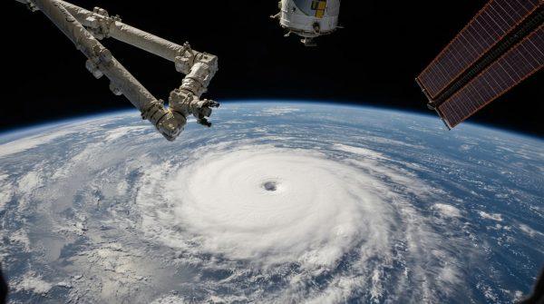
When Hurricane Polo began to churn in the eastern Pacific, few expected it to become the meteorological monster it did. But El Niño had other plans. The same climate phenomenon that often quiets Atlantic hurricanes can supercharge Pacific storms, and Polo was the perfect example. Exceptionally warm ocean waters, combined with near-zero wind shear, created a perfect thermodynamic laboratory for explosive intensification.
Meteorologists at NOAA and other agencies watched in awe as satellite imagery revealed cloud-top temperatures cooling at an unprecedented rate within Polo's eyewall. That cooling is a telltale sign of latent heat release—the fuel that powers a hurricane's engine. Within a remarkably short window, Polo jumped from a modest tropical storm to a major hurricane, with sustained winds surpassing seasonal thresholds. The storm's barometric pressure plummeted, confirming the immense rotational force generated by the thermal feedback loop.
How El Niño turned up the heat
El Niño's signature is warm sea surface temperatures across the central and eastern Pacific. This year, those temperatures ran significantly above average, providing an almost limitless supply of thermal energy. At the same time, wind shear—the atmospheric enemy of tropical cyclones—dropped to near-zero levels during Polo's peak development window. That combination effectively removed the primary barrier that usually disrupts storms before they reach maximum intensity.
"The ocean was basically a bathtub of warm water," said Dr. Mariana Reyes, a climatologist at the Universidad Nacional Autónoma de México. "When you remove wind shear and add that much heat, you get explosive growth. Polo was a textbook case of how El Niño can amplify a storm's power."
Computer models struggled to keep pace with the storm's rapid evolution. Forecasters noted that the sheer velocity of strengthening was unlike anything they'd seen in recent years. "We're used to gradual intensification," said a NOAA spokesperson. "Polo went from a tropical depression to a major hurricane in under 48 hours. That's a nightmare scenario for anyone in its path."
Impacts across the Pacific coast
The storm's fury wasn't confined to the open ocean. Coastal communities from México's Baja California peninsula to the shores of California felt Polo's effects. Wave heights exceeded 20 feet along remote shorelines, and marine navigation advisories restricted commercial vessel traffic across primary shipping lanes in the eastern Pacific. Rainfall totals surpassed 6 inches in 48 hours across elevated terrain near the storm's trajectory, raising the risk of flash floods and mudslides.
Emergency response agencies in México and the United States activated enhanced preparedness protocols. Swift water rescue units were deployed to staging areas ahead of predicted flooding. In California, officials monitored the storm's progress closely, mindful of the potential for heavy rain and coastal erosion even as the storm weakened. The triple threat of simultaneous Pacific hurricanes had already put communities on edge, and Polo's explosive growth only heightened concerns.
Oceanographic teams analyzed salinity profiles to understand how stratified water layers influenced the transfer of thermal energy into the lower troposphere. Meanwhile, reconnaissance aircraft flew directly into the eye of the storm, gathering dropsonde data that validated theoretical models about how El Niño boosts surface wind velocities. That real-time telemetry helped disaster authorities refine evacuation timelines for vulnerable coastal settlements.
Forecasting challenges in a warming world
Polo's rapid intensification exposed critical gaps in current meteorological prediction systems. Sudden surges of thermal energy in the ocean disrupt the stability of traditional forecast variables, drastically reducing the window for issuing precise early warnings. A storm that escalates from a minor category to a severe one within 24 hours leaves little time for communities to prepare.
"We're seeing more of these explosive events," said Dr. Reyes. "The ocean is warmer than it used to be, and El Niño is making it even warmer. Our models need to catch up."
Climate analysts stress that current oceanic variability demands constant updates to supercomputing platforms and real-time observation protocols. Some institutions are turning to artificial intelligence to process complex thermal anomalies before they become imminent threats. But even with these advances, the unpredictability of rapid intensification remains a formidable challenge.
For now, the Pacific coast breathes a sigh of relief as Polo moves into cooler waters and weakens. But the storm leaves behind a sobering reminder: as El Niño continues to shape our climate, the next explosive hurricane may already be brewing.