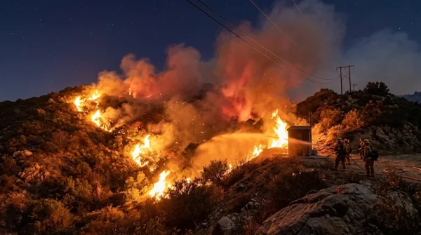
Southern California's wildfire danger remains high even as the Santa Ana winds that fanned the flames over the weekend begin to subside. The National Weather Service (NWS) confirmed that while wind speeds peaked on Saturday, the region is still in a precarious position due to extremely low humidity and prolonged heat that have left vegetation tinder-dry.
Meteorologist Rich Thompson, based in Oxnard, described the situation as ranging from elevated to critical, noting that gusts between 30 and 50 mph combined with historic drops in relative humidity have created a perfect storm for fire spread. "The winds are easing, but the dry air is still with us," Thompson said in an official briefing. "That means conditions remain favorable for fires to ignite and grow quickly."
Red flag warnings and dry fuels
A red flag warning was in effect from 2 a.m. to 6 p.m. on Saturday across the western San Gabriel, Santa Susana, and Santa Monica mountains, as well as the Santa Clarita Valley. During that window, relative humidity levels plummeted to between 8% and 20%, and critically, there was no overnight recovery—meaning the air stayed dry even after sunset. This left fine fuels like dry brush and grasses extremely vulnerable to rapid fire growth.
The Los Angeles Times reported that these conditions were most dangerous between Friday night and Saturday afternoon, when winds were at their peak. Even as the winds taper off, the lack of moisture in the air and soil continues to pose a significant threat.
Coastal impacts and surf warnings
The offshore winds didn't just affect fire danger—they also pushed dry air toward the coast, accelerating soil desiccation and straining emergency response teams. Ventura County was under a wind advisory that expired at 2 p.m. Saturday, but the effects lingered. Temperatures soared to nearly 90°F in some inland valleys, well above seasonal averages.
Along the coast, high surf warnings remain in effect through Tuesday morning, bringing dangerous rip currents and the possibility of minor coastal flooding during early morning high tides. These conditions are a reminder that the region's weather is interconnected, and the same pressure systems that drive the Santa Anas also churn up the ocean.
Forecasters expect daytime temperatures to gradually cool to around 80°F by midweek, but they caution that this minor cooldown won't eliminate the fire risk. "The moisture deficit is so severe that even a slight drop in temperature won't make a significant difference," Thompson added.
Looking ahead
Weather models suggest a shift toward a cooler, more unstable pattern by next weekend, with potential rain chances. That would be welcome news for a region that has seen little precipitation, but emergency agencies stress that continuous monitoring is essential. Communities across Los Angeles and Ventura counties should remain prepared for any resurgence of fire activity.
For those living in fire-prone areas, this is a good time to review evacuation plans and stay informed through local alerts. The Southern California coast has already faced its share of weather extremes this season, from record holiday flooding to this latest wind event. As the climate continues to shift, these patterns may become more frequent, making preparedness all the more critical.
In the meantime, residents are urged to avoid any activities that could spark a fire, such as outdoor burning or using equipment that creates sparks. The combination of dry vegetation and gusty winds means that even a small ignition could quickly escalate into a major blaze.
Stay safe, stay informed, and keep an eye on the sky—because in Southern California, the weather can change in an instant.