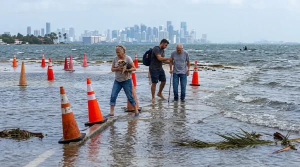
As the calendar turns toward Thanksgiving, Miami-Dade County is bracing for another round of king tides—those seasonal high tides that push saltwater into streets and low-lying neighborhoods even when the sky is clear. This year, the first surge is expected between November 6 and November 9, 2026, with a second window from November 23 to November 26. For locals who remember past floods, it's a familiar scene: seawater bubbling up through storm drains, cars stalled in brackish puddles, and the unmistakable smell of the bay mixing with exhaust fumes.
King tides happen when the gravitational pull of the moon and sun align with the lunar perigee—the point in the moon's orbit when it's closest to Earth. That combination raises ocean levels several inches above normal, and in a city built on drained wetlands, those inches are enough to overwhelm seawalls and drainage systems. The National Oceanic and Atmospheric Administration (NOAA) has been tracking these events for years, and their models show that this year's tides could be particularly strong, especially when combined with gusty winds or heavy rain.
What to Expect on the Streets
For drivers, the advice is simple: check the tide charts before heading out, and if you see water covering the road, turn around. "Don't drive through flooded intersections," warns Miami-Dade Fire Rescue. "Just a foot of moving water can float a car, and saltwater will ruin your brakes, electrical system, and undercarriage." Parking on higher ground before the peak tide is also recommended, as is a thorough freshwater rinse after the water recedes to prevent corrosion.
Pedestrians should also be cautious. Standing water in urban areas often contains oil, chemicals, and sharp debris—not to mention bacteria from overflowing sewers. Health officials advise against wading, especially for children or anyone with open cuts. "It's not just seawater," explains a county spokesperson. "It's a cocktail of everything that washes off the streets."
The impact goes beyond inconvenience. Local businesses in low-lying areas like Brickell, Edgewater, and parts of Little Havana see fewer customers when streets are flooded. "People can't park, so they don't come in," says a café owner in Brickell. "We lose a day's revenue every time this happens." And the damage isn't just to storefronts—repeated flooding undermines road foundations, corrodes underground power lines, and forces costly repairs that strain municipal budgets. As one recent analysis of Florida's tax cuts points out, finding money for flood defenses is becoming a political hot potato.
Planning for the Future
Miami-Dade County has been investing in pumps, seawalls, and drainage upgrades, but the pace of sea-level rise is outpacing infrastructure improvements. NOAA's Sea Level Rise Viewer is a useful tool for residents to see which streets are most vulnerable. The county also publishes interactive flood maps that update in real time during high tide events.
For now, the message is to stay informed and be patient. King tides are a natural phenomenon, but they're also a preview of what's to come. As one oceanographer put it, "What we call 'sunny day flooding' today will be the new normal tomorrow." For Miami's Latino communities—many of whom have deep roots in coastal cities like Havana, Caracas, or San Juan—this is a familiar story of adapting to the sea. But it's also a reminder that the fight against rising waters is a shared one, from the record flooding in Los Angeles to the El Niño-driven storms that have hit Florida in recent years.
So as you plan your Thanksgiving travels, give yourself extra time, keep an eye on the tide charts, and remember: when the water rises, it's better to be safe than sorry. And if you're looking for a silver lining, at least the sun will be shining—even if the streets are wet.