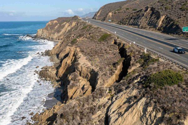
A dramatic fissure has appeared in the bluffs overlooking the Pacific Coast Highway between Laguna Beach and Newport Beach, forcing California transportation officials to shut down a southbound lane as a precaution. The crack, which runs parallel to the roadway near Crystal Cove State Park, is the latest sign of the relentless coastal erosion battering Southern California's shoreline this season.
Geologists from the University of California, Irvine, who have been monitoring the site, say the slope is actively shifting. The fracture, located near El Moro Canyon, emerged after a series of powerful Pacific storms and heavy surf pounded the coast. Caltrans engineers closed the lane closest to the cliff edge to protect drivers from a potential collapse.
A fragile lifeline for coastal communities
For residents of Laguna Beach and Newport Beach, the Pacific Coast Highway is more than a scenic drive—it's the main artery connecting their towns to the rest of Orange County. A full-scale landslide would cut off these communities from the mainland, forcing lengthy detours and isolating thousands of people. Local officials are bracing for that possibility.
“Stabilizing an oceanfront slope is a highly complex technical process,” said Laura Ezzell, a spokesperson for Laguna Beach. “Residents should prepare for lane closures that extend well beyond a few days.” Her warning echoes the concerns of experts who say the underlying instability is not a quick fix.
Professor Brett Sanders, a coastal engineering expert at UC Irvine, emphasized the severity of the situation. “The crack runs parallel to the road, which means a larger landslide could completely sever the highway,” he said. “That would be catastrophic for the towns that depend on this route.”
El Niño and the pounding Pacific
The current El Niño has brought a series of intense storms and record-breaking waves to California's coast. The combination of Kelvin waves and powerful swells has already caused significant damage in Malibu, Dana Point, and Long Beach, and has led to sudden flooding in Newport Beach. The record El Niño waves have also brought rare tropical fish to the region, a sign of how unusual this season is.
The erosion is not just a road hazard; it's a threat to coastal properties. Exclusive neighborhoods in Orange County have seen bluff-top homes lose chunks of their backyards, and the relentless surf continues to undermine the cliffs. The El Niño-driven changes are reshaping the coastline in ways that will have long-term consequences.
Emergency measures and long-term solutions
Caltrans is working around the clock to monitor the slope and assess the damage, but engineers admit that temporary fixes may not hold. The agency has installed sensors to track movement and is considering more permanent stabilization measures, such as soil nailing or retaining walls. However, these projects take time and money, and the clock is ticking.
Local officials are also urging the state to develop a comprehensive plan for coastal resilience. “We can't just react to each emergency,” said one county supervisor. “We need a long-term strategy to protect our roads, our homes, and our way of life.” The AwareCA app, recently launched by the state, could help residents stay informed about hazards like this one.
For now, drivers are advised to expect delays and use alternate routes where possible. The closure of the southbound lane has already caused backups during peak hours, and the uncertainty is weighing on commuters and business owners alike.
This is not the first time the Pacific Coast Highway has faced such a threat, but the scale of the current crack has raised alarms. As the climate continues to change and storms become more intense, the coast will only become more vulnerable. The question is whether California can adapt in time.
In the meantime, the community watches and waits, hoping that the hill holds and that the road remains open. The ocean, as always, is a powerful force, and this time it's winning.