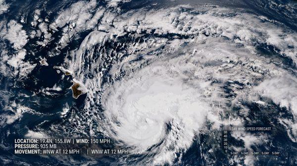
For decades, Hawaii has been seen as a safe haven from the worst of hurricane season. But this year, El Niño is rewriting the rules. The climate phenomenon, known for warming Pacific waters, is steering cyclones toward the islands in ways that have caught even seasoned meteorologists off guard.
Two consecutive systems have already struck the Big Island this season, a rare event that has pushed local authorities into high alert. The National Oceanic and Atmospheric Administration (NOAA) and other agencies are tracking unusual ocean temperatures that are redirecting storm paths. The result: a region that typically escapes the brunt of tropical weather is now facing real threats.
Why Hawaii is more vulnerable than ever
The danger isn't just the storms themselves. The Big Island's steep terrain and the nearly three feet of rain that have already fallen this season have left the ground saturated. That means even moderate rainfall can trigger flash floods and landslides. Forecasters are warning of an additional 3 to 6 inches in some areas, particularly on the eastern side of the island and parts of Maui.
"The combination of saturated soil and steep slopes creates a perfect recipe for disaster," says Dr. Elena Martínez, a climate researcher at the University of Hawaiʻi. "Every drop of rain becomes a potential trigger."
This isn't just a Hawaiian story. The same El Niño-driven patterns are being felt across the Pacific, from the coasts of México to the islands of the South Pacific. In the eastern Pacific, forecasters are monitoring several disturbances, including Invest 91E and systems near southern México that could intensify. Tropical Storm Iselle, meanwhile, is churning toward open waters with winds of 60 mph, generating dangerous swells along coastal areas.
Breaking historical patterns
What's most concerning to scientists is how El Niño is upending long-held statistical models. Historically, Hawaii has been shielded by cooler waters and wind patterns that kept storms away. But as ocean temperatures rise, those shields are weakening. "We're seeing a fundamental shift in how hurricanes behave," says Dr. Carlos Rivera, a meteorologist at the University of Miami. "The old rules no longer apply."
This unpredictability is forcing emergency managers to rethink their playbooks. In Hawaii, civil defense officials have ramped up public awareness campaigns and conducted drills to prepare residents for the possibility of a direct hit. "We're used to preparing for hurricanes on the mainland, but here it's a new reality," says Honolulu resident and community organizer, Kealoha Wong. "We're learning as we go."
The economic stakes are high. Beyond the immediate threat to homes and infrastructure, the storms are disrupting agriculture and supply chains across the islands. Farmers are facing crop losses, and shipping costs are climbing as vessels reroute to avoid rough seas. Financial analysts are advising businesses to diversify their supply chains and consider flexible insurance policies that cover climate-related disruptions.
For the broader Latino community, this story resonates beyond Hawaii. Many of our readers have family in coastal regions of México, Central America, and the Caribbean, where El Niño also brings heightened risks. The same oceanic and atmospheric forces that are steering storms toward Hawaii are also influencing weather patterns closer to home. As we've seen with La Niña's August grip on the US, these climate cycles have far-reaching consequences.
In the face of this uncertainty, one thing is clear: preparation saves lives. NOAA and other agencies are urging residents in vulnerable areas to stay informed and heed official warnings. For those of us who call the Pacific home—whether in Honolulu, Mazatlán, or San Juan—the message is the same: respect the ocean, respect the storm, and be ready.
As the season continues, scientists will be watching closely. The hope is that this year's unusual activity is an anomaly, not a new normal. But as Dr. Martínez puts it, "We can't afford to wait and see. We have to adapt now."