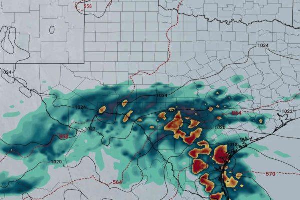
If you had plans to enjoy a quiet, sunny weekend across Texas, you might want to rethink them. A powerful low-pressure system moving out of the southern plains is set to collide with moisture from the Pacific, delivering a sharp cold front that will drop temperatures by as much as 50 degrees and bring widespread rain to the region.
In San Antonio, the mercury hit nearly 80°F on Thursday, but by Friday night, a northward shift in wind direction will usher in much cooler air. The National Weather Service forecasts highs only in the 60s for the weekend, with overnight lows dipping into the 50s. It's a dramatic turnaround that has residents dusting off jackets and digging out umbrellas.
Rain chances climb across the state
Precipitation probabilities are high, ranging from 70% to 80% for Saturday night and early Sunday. The urban corridor of San Antonio could see between 0.75 and 1.5 inches of rain, while areas further south—Laredo, Corpus Christi, and the Rio Grande Valley—may easily exceed 2 inches. Although the system lacks the instability to produce severe thunderstorms, the steady rain could lead to ponding on roads and minor street flooding in low-lying areas.
Wind gusts up to 30 mph will accompany the front, adding a chill to the air and making outdoor activities less appealing. The combination of rain, wind, and cooler temperatures is a stark contrast to the mild conditions earlier in the week.
What this means for your weekend
For families planning outdoor gatherings, sporting events, or trips to the park, it's wise to have a backup plan. The cold front will keep skies cloudy and temperatures cool through most of the weekend, with the low pressure system slowly moving out by Sunday afternoon. That's when the rain will taper off, but the cooler air will linger.
This weather shift is part of a broader pattern affecting the southern United States, and it's a reminder that Texas weather can change in an instant. For those who follow local politics, this weekend's chill might be a topic of conversation alongside the recent unusual election results that have captured national attention.
Residents are advised to take precautions: drive carefully on wet roads, secure loose outdoor items, and check on neighbors who may be sensitive to the temperature drop. The sudden change is a good excuse to stay indoors with a warm drink and catch up on the latest political shifts that are reshaping the state.
For those in the Rio Grande Valley, the heavier rainfall could cause localized flooding, so it's important to stay informed through local alerts. The good news is that the system is not expected to produce severe weather, but the rain and cooler temperatures are a significant change from the recent mild spell.
As the weekend progresses, the low pressure will move east, and by Monday, skies should clear and temperatures will begin to moderate. Until then, it's a good time to embrace the coziness of a rainy weekend, perhaps with a caldo or champurrado to warm up.
This weather event also highlights the importance of being prepared for sudden changes, a lesson that resonates with many in the Latino community who have experienced the unpredictability of nature in their home countries. Whether you're in San Antonio, Houston, or the border towns, staying informed and adaptable is key.
For more on how Texas is navigating other challenges, check out our coverage of the state's demographic shifts and the housing affordability crisis. These issues, like the weather, require attention and action.