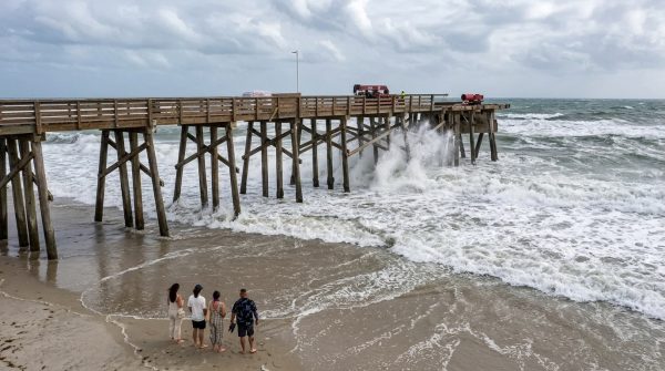
Florida's Atlantic shoreline is living up to its reputation this week as a powerful swell, driven by relentless northeast winds, slams into beaches from Palm Beach County down through Miami-Dade. The National Weather Service has issued high surf and rip current warnings that remain in effect through Thursday night, and local officials are urging everyone—locals and tourists alike—to take the ocean seriously.
Waves are forecast to reach between 7 and 12 feet in Palm Beach County, with Broward seeing 6 to 8 feet and Miami-Dade under a high risk for rip currents. These aren't just big waves; they're the kind that can knock you off your feet and pull even strong swimmers out to sea in seconds. The National Weather Service data confirms that sustained northeast winds of up to 28 mph are churning up the Atlantic, creating hazardous conditions across the region.
What's Behind the Rough Seas?
While Florida isn't in the direct path of any tropical storm, the National Hurricane Center is tracking a non-tropical low pressure system off the coast of North Carolina—designated AL93—that has a 40% chance of developing into a tropical cyclone. Even though it's far from Florida's shores, its interaction with regional wind patterns is helping to keep the ocean agitated. This system is a reminder that the Atlantic doesn't need a named storm to produce dangerous surf.
Local meteorologists are echoing the warnings. James Wieland, a Palm Beach surfer and weather enthusiast, posted on social media: "Gusty winds and huge swell on Palm Beach Island today! This sticks around all week and weekend too. Tides will be extra high along with some beach erosion with a lot of sand moving around. High surf advisory and small craft advisory much of the week." His observation aligns perfectly with official forecasts.
Safety First: What Beachgoers Need to Know
For those planning a trip to the coast, the message is simple: stay out of the water unless you're in a designated swimming area with lifeguards on duty. Rip currents are the biggest concern—they're narrow, fast-moving channels of water that can drag even the strongest swimmers away from shore. If you find yourself caught in one, don't fight it. Swim parallel to the shoreline until you're out of the current, then make your way back to land. If you can't escape, tread water and call for help.
Small craft operators are also being advised to stay in port, especially between Jupiter Inlet and Ocean Reef, where winds and waves are most severe. The combination of 28 mph gusts and 12-foot seas is no joke for even experienced boaters. And for those living in low-lying coastal areas, minor to moderate tidal flooding is possible during high tide cycles, so keep an eye on local drainage and weather updates.
This kind of weather isn't just a Florida story—it's a reminder of how connected our coastal communities are, from the unusual marine visitors that show up elsewhere to the everyday hazards we face here. For now, the priority is keeping everyone safe until the ocean settles down.
Officials are monitoring the situation closely and will update advisories as conditions change. In the meantime, if you're near the coast, enjoy the view from the sand, but keep your feet dry. The ocean will be back to its calmer self soon enough.